More on Route 66 - buying the North West USA this time
12 January 2008
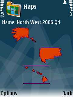
Yesterday I bought the North West USA map from Route 66. It took me a while to play border identification to determine which states were going to be covered but I was pretty confident that it had what I needed. For some reason, all you get when you look at a map within Route 66 is a map showing the shape of the areas to be covered, and the longitude and latitude of the top left hand corner and bottom right hand corner.
So, I went ahead and bought the map, and can confirm that for anyone else trying to find out what states are covered, that these are the ones: